Day 2, 4:00am, we awake from our comfy hotel sleep at the Albatross in Gander and don our hiking boots and lightly layered clothes as temperatures have been peaking at 30 degrees for the past week. With pre-daylight hours offering the coolest temps we waste no time and opt for a quick Tim’s coffee and bagel to fuel our morning adventure. This is a day we have been looking forward to for a long time, as it combines two things that each of us love, hiking and airplanes.

With a full tank of gas we are off in search of the Sabena DC4 plane crash site, deep in the interior of a dense coniferous forest, 35kms SW of Gander Lake, as the crow flies. Before I get into the details of this little adventure, it is probably best that I set the geographical and historical stage so to better comprehend the severity and magnitude of this aviation tragedy.
In the 1940’s Gander International Airport was known as the “crossroads of the world”, serving as a re-fuelling stop for transatlantic flights between North America and Europe, pre and post WWII, as larger jets were not yet invented.
It was in the early hours of September 18th, 1946, when Belgium’s Sabena Airlines Douglas DC-4, enroute from Brussels, Belgium to New York, was told to prepare for landing at Gander’s International Airport after a bumpy ride over the Atlantic. With a northerly wind and a cold, damp fog blanketing the landscape, the pilot, while preparing his approach, made the decision to fly below the clouds in hopes of obtaining better visibility for landing. Sadly, this fly-by-sight method became the pilot’s gravest mistake as the DC-4, enveloped in the unforgiving fog, crashed into the rugged hills and dense forest of Newfoundland’s vast and desolate interior.

The largest and most modern civilian airliner of its time, carrying 44 passengers, would come to its demise in an unimaginable horror; 26 lives were loss as a result of the impact and 18 others survived, though some probably wished they hadn’t as the next 4 days would prove to be a living hell on earth.
With knowledge of the planes disappearance, it took Search and Rescue several days to even locate the wreckage. And as details of the remote crash location came to light, the daunting task of implementing a rescue effort seemed, at times, impossible. But what came to pass over the next several days was nothing short of a miracle.
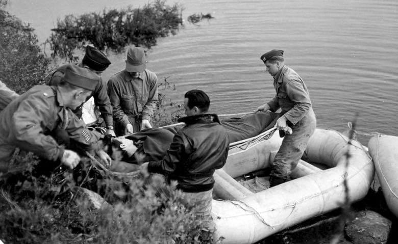
Before I reveal how this extensive recovery effort unfolds, it is important to pay respects to the two caribou hunters from Glenwood, Mr. Pelley and Mr. Shea, who were the first responders on the scene. As they bared witness to a tragedy beyond anything one could ever imagine; smoldering wreckage, bodies strewn over the burning ground, some entangled amongst twisted metal, others incinerated in their seats. Yet throughout the night they aided the survivors, providing them with hot tea, blankets and the warmth of a fire to keep them comfortable until ground crews arrived. Among them, Dr. Martin from the Argentia Naval Base, who also worked tirelessly to keep survivors alive.
As emergency supplies were dropped by parachute, a relentless rescue mission was underway. Not only was it the first time helicopters were used in Newfoundland, it was also the first time helicopters were used in any civilian aviation rescue operation in the world! Amazingly, with no helicopters in Newfoundland, two Sikorsky-manufactured helicopters in the United States (one from New York and the other from North Carolina), were dismantled, put on a plane, flown in to Gander Airport, reassembled and used to transport survivors out … one at a time. With a makeshift camp set up near the crash site, wooden platforms had to be constructed for the helicopters to land on so they wouldn’t sink down through the bog. From camp, the helicopters transported the victims 12 miles to Gander Lake where they were loaded into life rafts, paddled to a PBY seaplane and flown to Gander Airport. From there they were transported by ambulance to Gander hospital. In total, the 2 helicopters made a total of 40 trips in order to drop supplies, evacuate survivors and return rescuers to Gander once the mission concluded. Simply amazing.


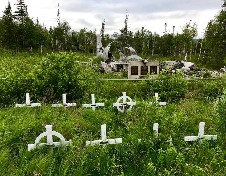
Due to the immense difficulty of rescuing the survivors, it was decided that the 26 individuals who died in the crash were to be laid to rest here, the site known today as ‘St. Martin in the Woods’ in honour of Captain Samuel P. Martin, MD, US Army Medical Corp.
Later, Sabena Airlines would erect markers, the Star of David and white wooden Christian Crosses.
***hover over photos for additional comments***
The Road and Trail


The Sabena Wreckage


The Cemetery


Getting Here
Getting to the Sabena Plane Crash Site turned out to be not as easy as we thought, which is why I began this blog on Day 2. Day 1, the morning prior, was forfeited due to not necessarily lack of planning, but rather lack of up-to-date Google Earth satellite imagery, and some misinformation, that omitted important structures like a bridge (that now exists) and the higher grade Nalcor transmission line service road.
Secondly, this unpublicized, densely wooded area is an endless maze of old logging roads dating back to the early 1900’s, forestry branch roads, and countless cabin trails. It is an area not to be taken lightly as cell phone coverage is practically nonexistent once you detour off the highway.
Day 1’s attempt in an all-wheel drive Subaru Outback took us 50 kilometres over washboard, loose gravel roads (with an anticipated 14km hike). With no additional equipment like an ATV or side-by-side to navigate tight, overgrown alder trails and significant rivers, we decided to turn back when we came upon a small, sketchy looking wooden bridge accompanied by a tiny hand-painted sign that read “quads only”. Frustrated and confused we retreated back to the TCH to recollect our thoughts. From there we decided it best to drop by the Glenwood Town Office in hopes of obtaining additional information or an alternate route.


CAUTION: The Sabena Airlines plane crash site can be accessed by several modes of transportation: 4X4 or AWD; Truck or SUV; Quad or Side-By-Side; and/or on foot. Depending on your choice of transport and the route you take (there are several), distances to the site will vary. Overall, the region is a virtual maze of mainly unsigned gravel roads, even the Sabena signs lend to a minimalist design, as you will not see this site promoted anywhere as a Newfoundland tourist attraction. With that said, GPS is a must! Always carry a cell phone (as a signal could be possible), a first aid kit, bear spray (it is bear territory), and sufficient food, water, clothes for changing weather conditions. And to be on the safe side, ALWAYS let someone know of your plans before you leave.
In summary, this excursion took us 120kms over gravel roads (return trip) and a 7kms return hike.
(NOTE: For current information or directions I would recommend you seek advice from the Glenwood Town Office or locals familiar with the area, as road conditions, bridges, and accessibility to the site may have changed since this article was written).
Happy Trails!


I would love to go see this! Is the route you took the one from the photo posted? Hoping to get out there this summer in my SUV. I would love to hear more details about the drive there.
LikeLike
Thank you Jed! … there are quite a few plane crash sites on the island. This one is a little more challenging to get to. It’s nice to do something off the beaten path sometimes. 🙂
LikeLike
Nice read Diane! Man you never know where your boots 🥾 are taking you. I never knew about this crash thanks for sharing
LikeLike
Hi i am planning a trip with descendants of people who died in Sabena Crash 1946 I want to know if you can help us with information on how to get there and where to acquire vehicles
LikeLike
I sure can. Did you want to give me an email address? Easier to correspond that way.
Where are you living? In Newfoundland?
Look forward to hearing from you.
Diane & Bill
LikeLike
My friend is Sam P Martin IV, MD, son of Dr Martin III, and I am was an Helicopter pilot in the Army (born in St Johns, Newfoundland). I have made a promise to myself that before he is not able I will take him there. Please let me know if you can help me with this journey within the next year. Suggestions for outfitters maybe be best as his family and I would not want him making this trek unguided, he is 74 and a wonderful man that has his dads kind character and tenacious grit.
LikeLike
Hello Mr. Sapp, It has been a few years since we did this drive/hike to the Sabena Plane Crash Site. And as my article stated, it took us two attempts to get the directions right. We were successful on the second day getting there. I would suggest that you contact the local Glenwood Town Office to inquire about asking a resident to take you in there as you will need an AWD or 4-wheel drive vehicle. I do have not current information on the gravel road conditions. Once you get to the trailhead, you have a few kms walk into the site, or you would have to have an ATV to get in there if there are mobility issues. I wish you all the success in making this trip happen.
LikeLike
Enjoyed reading about your hiking journey to the crash site of ,”The Sabena Airlines Plane Crash”
LikeLike
Thank you Maxine 🙂
LikeLike
Thank you for sharing ! After all these years I am sad to say I haven’t made it to the site. My grandfather Abbott Pelley (Mr. Pelley) was one of the first hunters on the scene. You are indeed right when you say the events of this crash took a toll on the hunters
LikeLike
Wow! It is amazing to get a response from you. Thank you! Your grandfather, I’m sure, was a very special man. There is no doubt that his experience stayed with him forever.
LikeLike
Great read 🙂 this story means so much to me as it was my great grandfather, Abbott Pelley, who was 1 of the 2 men who helped the survivors that night. We have been there many times.
LikeLike
thank you Nicole 😉 It must of been quite the ordeal for your grandfather. They did so much for them, with so little. God bless them both.
LikeLike
This site should be promoted as a tourist attraction with easier access.
LikeLike
Sabina Crash Site should be promoted, great story, Thanks.!!!
LikeLike
thank you 😉
LikeLike
Been there myself, several times during Moose hunts in the area. Definitely a sobering experience to see all the grave markers and the wreckage.
LikeLike
It certainly is. It was something we wanted to see, but when you do it’s like … “oh my”.
LikeLike
I have been in there several times. I am glad to see someone took the time you log about this on here. Great job guys.
LikeLike
Thank you Sheldon! We wanted to see this for a few years. It is a sobering site.
LikeLike
Hi Sheldon we have been reading about your trip into the Sadena crash site. we would love to to to you about it. It’s something that have interested us for a long time.
thanks Sheldon.
LikeLike
Thank you 🙂
LikeLike